Strategy for Deep Sea Communication
or Safe Fisheries – mKRISHI®
Fisheries, a Case Study
Dineshkumar Singh1,*, Sanjay Kimbahune1 and Veerendra Veer Singh2
- 1Innovation Lab – Mumbai, Tata Consultancy Services Ltd., Yantra Park, Thane, India
- 2Mumbai Research Center of CMFRI, Old CIFE Campus, Andheri, Mumbai, India
E-mail: {dineshkumar.singh; sanjay.kimbahune}@tcs.com; veerendraveersingh@gmail.com
*Corresponding Author
Received 2 March 2017;
Accepted 8 March 2017
Abstract
Fishing is one of the most dangerous professions in the world. India with one million active fishermen population still lacks a reliable boat-to-shore communication network. Fishermen with smaller boat are more vulnerable to the wilder nature of the ocean, due to dynamic sea current, wind speed, direction and wave heights, etc. They form 80% of the entire fishing community. There being no physical boundary, the risk of fishermen accidently getting in other country’s terrestrial water, is very high. Hence, the fishermen and their families are always concerned about the safety of the human lives, boat and gears. Due to deep sea communication network we can continuously get oceanic condition information. Such real-time information about wind speed, direction and wave height can help to estimate the risks and avoid the ocean region which seems dangerous. As part of this initiative, we looked at various available communication technologies like VHF transceivers, satellite communication and cellular mobile communication. Central Marine Fisheries Research Institute, Tata Consultancy Service and Tata Tele Services formed a consortium and piloted a project to extend the mobile signal deep into the sea up to 30 kms. This extended network enabled continuous accessibility of life saving ocean state forecast information provided by INCOIS. Due to this an accessible Early Warning System (EWS) spread over a digital highway of 30 by 120 km, along Raigad coast. This paper captures the experiences and recommendations derived from this pilot.
Keywords
- Fisheries
- mobile
- deep-sea
- communication
- EWS
- security
1 Introduction
1.1 About Indian Fisheries
India contributes 5.68% of the world’s total fish production [1]. Indian fisheries sector contributes 0.83% to the Indian GDP [2]. It is a major source of livelihood for 0.9 million active fishermen and another 3.5 million from the allied sectors like fish processing and marketing. It is only livelihood for 3202 coastal villages. 61 percent of the population is below poverty line with annual income less than 25,000 Indian Rupees (US$400). Education level is very low and majority of the population have limited education, either upto 4th or 10th standard. Hence finding an alternate livelihood is always a challenge. The situation becomes more difficult during the lean period or monsoon ban period. These factors increase the risk of dependency on the moneylenders to meet and for emergency needs [4]. The work division makes male member of the family to go on the boat and hence become the primary bread winner. Hence his safety is of utmost importance for well-being of the entire family. Sea worthiness depends on the combination of multiple parameters such as wind speed, its direction, wave height and swells. At times it can become dangerous and hence the vulnerability for those at sea increases. If there is a sudden weather change, it is very difficult to manage the small boats especially when is loaded with the fish catch [5]. International Labour Organization’s 1999 report estimated that approximately 24 million fishermen per year face non-fatal injuries [6].
During 1891 to 2000, 308 cyclones have hit the coastal population of East India [7], endangering the lives of 370 million within the 100 kms off the coast. This calls for the design of a multi-technology communication framework to facilitate an Early Warning System (EWS) for the fisher folks and the other coastal population.
1.2 About INCOIS PFZ and OSF Services
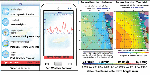
Indian National Centre for Ocean Information Services (INCOIS) provides oceanic information such as Potential Fishing Zone (PFZ) and Ocean State Forecast (OSF) Advisories (Figure 1) for Indian coastal region [8]. These are derived from the Chlorophyll and TSM images received from Oceansat-2 and Sea Surface Temperature (SST) images from NOAA-18/19 and MetOp-A/B satellites. These images are geometrically corrected, filtered and are geo-coded. The PFZ map information helps fishermen to identify the pelagic fish shoals and plan their fishing trips [4].
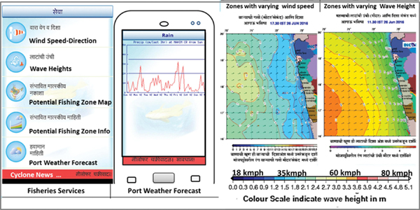
Figure 1 mKRISHI® Fisheries service with OSF services PFZ, wind speed and wave height. Red indicates high wind speed (danger zone).
Each service is the representation of the temporal and spatial aspects of the sea. OSF consists of the range of wind speed and direction, swells and wave height (Figure 1). A day is divided in four six hour interval and for every internal i.e. 0530 hours, 1130 hours, 1730 hours and 2130 hours images are generated. Hence these images are generated four times a day, for five days in advance. Each image represents the different wind speed range (or wave height range) with different colour intensity. Dark blue and lighter shades of blue are considered safe region to cruise whereas shades of green, yellow are considered unsafe and red and white regions are considered highly vulnerable.
1.3 Challenges in Information Delivery
Educational and computer literacy, both are low in the fishermen community. Electricity is not available 24x7. But mobile phone penetration is more than 70%. Hence, mKRISHI® Fisheries, a Java (J2ME) and Android mobile based apps were developed for the fishermen to transfer the OSF and PFZ information. This mobile app translated the information in the local regional language (Marathi) during service pilot in Raigad district of Maharashtra (India) with 56 fishermen societies.
1.4 Benefit
Advance PFZ image helped fishermen to identify the pelagic fish shoal location, estimate the trip duration, the fuel quantity, amount of ice and no. of labour etc. Wind speed image helped them in finding out the areas where sea will be turbulent. This brought more discipline in the trip planning and risk assurance, leading to savings in 30% diesel, cost and life [9]. Planning the boat cruise, in the direction of the wind, reduced the drag on the boat and hence improved the diesel efficiency, further reducing CO2 emission and cost of catch. This made the fishing safer and sustainable.
1.5 New Challenge
Fishermen complained that the information could not be updated while they were at deep sea, especially during multi-day trawling of up to 10 to 15 days. The mobile data network is available only up to 5–8 km in the sea. This limited the use of the Early Warning System (EWS) services. Hence, research was required to identify the modes of communication which can be extended deeper in the sea.
2 Material and Method
We looked at three modes of the Information and Communication Techno- logies (ICT)
- Wireless (VHF) Transceivers (popularly known as Walkie-talkie).
- Satellite based communication (Satellite phones and Direct To Home (DTH)).
- Mobile telephony (using cellular technology – 2G GSM/CDMA).
The study included the structured interview of the equipment manufacturers and service providers, existing users in the fisheries sector, regulating agencies, etc. The questionnaire included the ease of use, equipment cost, operational cost, affordability, constraints etc. This was followed by a scientific study of the technical specification, coverage/range [10].
2.1 Wireless Set/Ultra or Very High Frequency (U/VHF) Transceivers
Few fishermen used the portable two ways radio wireless transceivers based on Very High Frequency/Ultra High Frequency. The major drawback of this technology is:
- generally asynchronous, one-way communication,
- need for the license, specific equipment, unlicensed operators,
- can cause signal interference to licensed stations,
- Most of the equipment supports only voice, limited text and no graphics/image.
2.2 Satellite Based (Satellite Phones and Direct to Home (DTH))
Satellite based DTH service, could be an alternative, but transmission is only one way and in narrow band – which is costly. In Ku Band Antenna position stabilization at sea is a big challenge.
2.3 Mobile Phones (Using Cellular Technology – 2G GSM/CDMA)
The major challenges of mobile phone technology are as follows:
- High initial capital expenditure to install towers and offer signal towards the sea.
- Telecom operators do not see a business in “seeing towards the sea” as Return On Investment (ROI) is challenging [11].
But it has several advantages:
- It has well established ecosystem of mobile handsets, telecom service providers, skilled labour, mobile apps and hence making the service affordable and popular.
- It is high speed growth industry; enabling more innovation in computing, performance and features at highly reduced price.
- Extending existing land based network to the sea can provide a seamless access.
- It offers both voice and data network.
- No learning curve and would also benefit the existing investment in the people/skill (to support the network) or use the services.
This sector is continuously evolving. Ongoing research in mobile operating system, application marketplace and apps like mKRISHI® Fisheries will fuel it further. Tata Teleservices Ltd. (TTL) eventually decided to conduct a pilot to extend the mobile signal in deep sea in the Raigad district of Maharashtra.
3 Experiment and Results
The pilot was divided in following four major phases:
- Proof of Concept (PoC) study and Boat Test Drive
- Selection of appropriate cellular technology (CDMA or GSM)
- Mobile Tower installation and commissioning
- Parametric test based detailed study of major operator’s signal
3.1 Proof of Concept (PoC) Study and Boat Test Drive
TTL modified the orientation of two sectors of the antenna on one tower to direct GSM (1800 MHz) and CDMA (850 MHz) signals towards the sea
During the first test drive, a baseline study, a fishermen boat was hired and the telecom RF engineers, fishermen and the Central Marine Fisheries Research Institute (CMFRI) scientists carried out an 11 hour boat cruise to test the signal strength in the deep sea.
Following instruments were used for the test drive:
- Automatic voice and data call testing (CDMA/GSM)
- Global Positioning System (GPS) devices
- Mobile Phones (for Voice and Data calls)
- Automatic & Manual Trackers (Call setup, Quality, data speed, etc.)
- Observation log books
One of the major observations was that in spite of having a dedicated tower to radiate the mobile signal towards the sea, the earth curvature will restrict the line of sight and hence the signal availability to 25–30 km.
TTL RF Engineers adjusted the antenna power level (in dBm), height of the tower and the direction of the antennas at two different sites. This helped to narrow down the testing parameters such as technology (CDMA vs. GSM), frequency, and tower height.
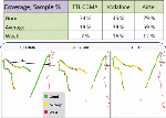
During third test drive, TTL installed one CDMA 850 MHz Base Station Transceiver System (BTS) at Sasawane and Varsoli villages, each. It also installed one CDMA + GSM BTS 1800 MHz at Borli-Mandla village. The objective was to choose correct cellular technology and BTS type to achieve maximum distance in the sea. See call and data quality plots in the Figure 2. The results have been summarized in the Table 1.
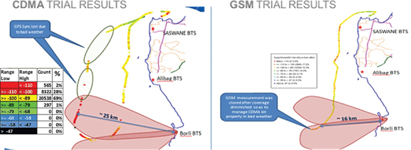
Figure 2 Boat test drive 3 – Test results
Table 1 Boat test drive 3 – CDMA and GSM tower call results (dBm).
3.2 Selection of the Cellular Technology
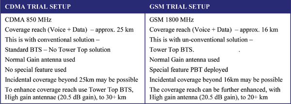
Based on the various test drive results, it was finally decided to move ahead with the CDMA technology for the pilot. The major factors which influenced the decision were:
- Link budget: Lower the band, good is the quality. Since TTL has CDMA towers in lower band i.e., 850 MHz, we observed that reach of CDMA tower signal will be higher than the GSM technology towers.
- Processing gain: CDMA technology employs processing gain concept which helps in increasing the coverage.
- Quality: CDMA technology has superior quality by virtue of soft handoff.
- Data speed: Data speeds are higher in CDMA technology because of its robust design. This is crucial to access the mKRISHI® Fisheries mobile app over the air.
- Signal/Noise Interference (S/N): CDMA is less prone to interference In GSM, managing interference in open area like sea is a big challenge.
- No. of calls: CDMA enables more simultaneous calls than GSM.
Government mobile service provider BSNL participated in the fourth test drive. It directed one sector of the antenna at its Saswane GSM 900 MHz BTS towards Arabian Sea. This tower was at a height of 35 feet and approx.150–300 m from the coast. Due to modification, mobile signals could be received up to 17 km in the sea. Signal modeller projected that by increasing tower height to 100 feet, we can get signal up to 35 km.
This study helped in deciding the parameters which can influence the range of the mobile signal. The parameters are as below:
- Mobile technologies (GSM vs. CDMA) and Spectrum (800 MHz vs 1800 MHZ)
- Tower height
- BTS type, feed antenna length, antenna type, angle and radiation power level
- Type of handsets
3.3 Tower Installation and Commissioning
TTL network planning team surveyed the Raigad mobile towers site location and identified 7–8 probable sites which will be modified to expand the signal up to 30+ km in the sea. On six existing towers, CDMA 850 MHz Tower Top BTS (Feeder less) with Std. 33deg antenna – High Gain ∼20.5 dBm were installed. Also a new tower was erected and commissioned to achieve a continuous 30 km by 120 km mobile signal network along entire coastline of Raigad district. The new site had tower top BTS with MRFU V2 900 MHz CDMA Antenna, supporting 4 TRX, 20W TOC, 25 MHz IBW).
3.4 Parametric Test Based Comparative Study of Major Operators’ Signal
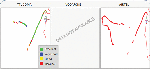
A comparative study of three popular telecom service provider’s mobile network was done. The comparison consisted of service’s quality, coverage and data speed. Three test drive kits were prepared to capture TTL CDMA, Vodafone and Airtel GSM network coverage parameters. We cruised towards deep sea in west direction for approx. 32 km.
3.4.1 Coverage comparison
Following signal strength parameters were compared:
- TTL CDMA – MTx Level (Transmit power level)
- Vodafone GSM – Rx Level (Receive power level)
- Airtel GSM – Rx Level
In CDMA, MTx Level produces true coverage indicator while comparing with GSM coverage. It will have better correlation than Rx Level under unloaded condition. It was observed that TTL CDMA coverage was continuous whereas the coverage plots of service provider Vodafone and Airtel seem to be patchy and discrete (Figure 3).
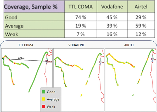
Figure 3 Signal coverage comparison.
3.4.2 Quality comparison
The ratio of the received energy per chip (= code bit) and the interference level were compared with the signal strength level.
- TTL CDMA – Ec/Io Level (
Energy perchip toInterference power ratio) - Vodafone GSM – AMR C/I Level (Adaptive Multi-Rate, Carrier to Interference levels)
- Airtel GSM – AMR C/I Level
These parameters represents the network and call quality considering the quality degradation due to signal interference. Additionally, FER parameter of TTL CDMA was compared with Rx Qual (sub) parameters of GSM operators. Rx Qual (sub) is considered to be crude way to indicate quality as it shows only idle scenarios. It was observed that TTL CDMA signal has superior quality compared to Vodafone and Airtel (Figure 4). Vodafone signal quality deteriorated as the distance increases from the coast. Quality of Airtel mobile signal was found to be patchy and degraded with the increased distance.
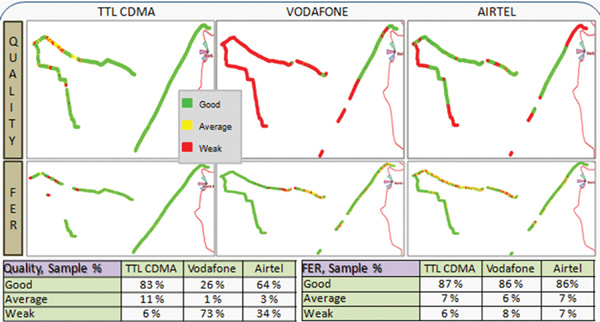
Figure 4 Signal quality comparison.
3.4.3 Data speeds comparison
Same parameters used above, to indicate the network and call quality, and additionally, Forward Link Frame Erasure Rate (FER) parameter of TTL CDMA compared with Rx Qual (sub) parameters of GSM operators gives the quality of data speed. It was observed (Figure 5) that TTL data speeds are higher due to selective deployment of new EVDO technology, giving good data speeds and customer experience. Airtel data speeds are lower as it works on GSM (2G) technology and can improve if they deploy 3G technology equipment.
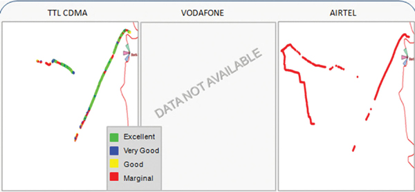
Figure 5 Signal data speed comparison.
Above results were based on the performance of all the telecom service providers in the region on given day of test drive. During test drive we covered only 3 sectors (out of 19) installed by TTL. A periodic test drive can help optimize the signal strength further.
4 Conclusion
The pilot project helped showcase that it is indeed possible to extend the mobile signal deep in the sea up to 30–35 km. This helped in understanding the parameters, approaches and investment required to achieve this. This presented a case study for all other telecom operators and also government to do a cost-benefit analysis to create similar infrastructure across all nine coastal states of India. Deep sea network helped in extending the accessibility to the ICT network which enabled a high adoption of the technology for a better livelihood and safety management. Fishermen used the extended signal to call for help when a boat was overloaded with the catch and could have drowned in the sea. An empty boat was dispatched which transferred the excess load and thus created a shared opportunity for all. In another instance, fisher with the large quantity fresh fish connected with the local on land traders. They negotiated the price while still at sea. This helped to preserve the quality of the fish and adequate ice, labour and truck could be arranged, even before the catch landed at the sea. A combination of the wireless VHF sets and mobile phones provided a further extended extension in deep sea, up to 60–70 km. This pilot experience presents a model for extending the early warning system using ICT in deep sea.
References
[1] Gopalakrishnan, A., and George, G. (2016). Marine fishermen: experiences and expectations. Blue Waters 17, 12–14.
[2] Handbook on Fisheries Statistics (2014). Available at: http://dahd.nic.inpp
[3] The World Bank (2010). India Marine Fisheries Issues, Opportunities and Transitions for Sustainable Development. Agriculture and Rural Development Sector Unit South Asia Region. Washington, DC: World Bank, 11–19.
[4] Sathiadhas, R., Panikkar, R. K. K. P., and Kanakkan, A. (1994). Traditional fishermen in low income trap – A case study in Thanjavur coast of Tamil Nadu.’ Marine Fisheries Information Service, Technical and Extension Series. Rome: FAO, 5–10.
[5] Anabel, Nancy. (2013). Enhancing Lives and Livelihoods of Fisher Folk Through Innovative Technology Applications. Singapore: Institute of Southeast Asian Studies.
[6] FAO (2010). Safety for Fishermen: The Way Forward. Rome: FAO.
[7] Sanjay, C., and Sakhuja, V. (2015). Climate Change and the Bay of Bengal: Evolving Geographies of Fear and Hope. Singapore: YusofIshak Institute.
[8] Shailesh, N., Kumar, T. S., and Kumar, M. N. (2007). Satellite based fishery service in India. Full Picture, 256–257.
[9] Sanjay, K., Singh, V. V., Pande, A., and Singh, D. (2013). “ICT for fisheries – Environment friendly way: Pilot experience in Raigadh,” in Proceedings of the 2013 Annual IEEE India Conference (INDICON), IEEE, Rome, 1–8.
[10] Singh, D., Veer Singh, V., Pande, A., and Kimbahune, S. (2015). “Approach and challenges for deep sea communication for fishermen – an experiment,” Proceedings of the 1st World Ocean Science Conference, Paris.
[11] Economic Times (2012). Can’t Force Operators to Give Coverage in Sea: DoT to Defence. New Delhi: Economic Times.
Biographies
Dineshkumar Singh completed his B.E. in Electronics Engineering from Mumbai University in 1996 and M.Tech. in Software Engineering from BITS Pilani (India) in 2015. He has two decades of IT industry experience, related to telecom core switching and network management and ICT for Society. Currently he is the Group Leader at Tata Consultancy Services Research and Innovation Lab – Mumbai and leads the innovation delivery for the agriculture, fisheries and livestock program. His work involves interaction with the diverse group of the stakeholders, research translation to the field, prototyping, pilot and expansion to the larger group. He has won prestigious National Social Innovation Award 2017 from Ministry of External Affairs, Govt. of India for the Fisheries program. He has published 20+ national and international conferences and journals papers in Springer, IEEE, ACM and CSI. He is member of IEEE and CSI.
Sanjay Kimbahune received is B.E. degree in Electronics from Amravati University with Honors. He is working as Senior Scientist in TCS Research and Innovation. He has experience of 27 years in diverse fields of CTI, Video Conference solutions, Mobile applications for masses. He has published 25 papers and has 8 granted patents. He was instrumental in developing mKRISHI® – a digital platform for farmers. mKRISHI® has reached about 1 million farmers as well has received many prestigious awards. His current research focus is remote scalable pathology for masses and ways to reduce child/maternal mortality in remote areas. His paper on the smartphone compatible low-cost water monitoring system for rapid detection of total coliform and E. coli has been published in prestigious Journal of Royal Society of Chemistry.
Veerendra Veer Singh completed his B.Sc. and M.Sc. in Zoology (Fish & Fisheries), Agra University India (in 1976 and 1978). He completed his Ph.D. in Life-Science (Zoology) from Barkatullah University, Bhopal (India) in 1989. He is working in ICAR Central Marine Fisheries Research Institute (CMFRI) since 1986 on Fishery environment, oceanography, remote sensing, GIS, Coastal Zone Management, Fishery diversity & forecasting and coastal consultancy. He is currently Scientist-in-Charge of Mumbai Research Centre of CMFRI. He has worked on identification of potential Mariculture sites along the Indian coast. He has conducted number of outreach activities for stakeholder, fishers and farmers including workshops, seminars, brainstorming sessions, demonstrations and participatory research. His collaborative innovation mKRISHI® Fisheries won the prestigious National Contest on Social Innovation 2017 organized by Ministry of External Affairs, Govt. of India.
Journal of ICT, Vol. 4_3, 199–212.
doi:10.13052/jicts2245-800X.432
© 2017 River Publishers. All rights reserved.