In-Between Landscape Transformations and Tourism Development: Investigating Latent Trends in Long-term Wildfires’ Patterns, Greece (1955–2024)
Ioannis Konaxis
Department of Tourism Studies, University of Piraeus, 80 Karaoli & Dimitriou, EL-18534 Piraeus, Greece
E-mail: ikonaxis@unipi.gr
Received 27 January 2026; Accepted 12 February 2026
Abstract
Global environmental change has increasingly reshaped wildfire dynamics resulting in heightened ecological and socioeconomic risks worldwide. While fire suppression and technical prevention remain central to wildfire and landscape management, broader land-use and governance frameworks are recognized as influential determinants of fire impacts at landscape scales. The present study investigates a long-time series (1955–2024) of wildfire basic indicators (burnt area, fire density, average fire size) with the final aim at deriving latent information clarifying change processes associated with climatic stressors, land-use change, and rapidly evolving socioeconomic conditions in Greece, a Mediterranean country with specific land-use trajectories, social dynamics, economic performances, and governance-related factors. Using an empirical approach based on multivariate statistics, this study evaluates the relative contribution of temporal variability in wildfire pattern as an indirect reflection of anthropogenic pressure. In this perspective, insights from existing literature and field-based observations are integrated to support interpretation of the quantitative results based on official statistics and landscape analysis. Wildfire risk seems to grow in the recent decades, both for fire size and frequency. These results underscore the relevance of integrated landscape management policies safeguarding agroforestry systems, and cross-sectoral measures fostering resilient and functional Mediterranean landscapes.
Keywords: Fire size, time pattern, land-use, correlation coefficients, Mediterranean.
Introduction
Wildfires constitute a complex phenomenon emerging from the interactions among ecological, physical, and human-driven factors (Moritz et al., 2005). While regional climatic conditions provide a broad framework for fire occurrence, local weather variability and the intrinsic flammability of landscapes play critical roles in shaping fire behavior, intensity, and spatial distribution (Fernandes et al., 2016; Turco et al., 2019; Pereira et al., 2020). Beyond environmental determinants, human activity modulates frequency and magnitude of wildfires (Mantero et al., 2020). Among these anthropogenic drivers, urban development – have emerged as key factors affecting fire dynamics (Moreira et al., 2011). In addition, rural socioeconomic practices, such as grazing, cultivation, and timber extraction, contribute to spatial and temporal variability in fire risk (Garcia-Ruiz et al., 2020), while governance frameworks and wildfire management policies further regulate landscape susceptibility to fire disturbances (Humphrey et al., 2021).
Although a considerable body of research has explored the localized effects of direct fuel management interventions – including prescribed burning and operational treatments – on fire behavior (Espinosa et al., 2019; Cansler et al., 2021; Stritih et al., 2021), understanding their indirect and landscape-scale consequences remains methodologically and conceptually challenging (Dale, 1997), particularly when aiming to identify general patterns from long-term fire indicator series. In Southern European contexts, empirical studies evaluating fire impacts remain relatively scarce, and most have relied on modeling or simulation approaches to examine hypothetical management strategies (Regos et al., 2016; Sil et al., 2019; Campos et al., 2022).
This study focuses on Greece, providing a robust context for assessing how landscape properties and temporal changes influence wildfire outcomes across complex fire-prone systems (Ferrara et al., 2019; Ascoli et al., 2021; Elia et al., 2022; Malandra et al., 2022). However, these studies have typically relied on relatively short time series and have focused on isolated subsets of potential drivers – for instance, socioeconomic conditions (Mancini et al., 2018), climatic variability (Cilli et al., 2022), or land-use dynamics (Ascoli et al., 2021) – without integrating them into a framework capable of capturing their interactive effects. Furthermore, empirical evidence quantifying the influence of indirect land governance interventions, whether planned or spontaneous, on the structuring of wildfire regimes is still extremely limited (Colonico et al., 2022).
To address these gaps, we implemented a multivariate analytical approach designed to quantify temporal variability in wildfire impacts across Greece, explicitly incorporating a comprehensive suite of environmental and anthropogenic covariates (Moreira et al., 2020). This framework indirectly accounts for natural drivers – including climate, fire weather indices, and landscape flammability – alongside human-related factors, such as socioeconomic context and land abandonment patterns. Importantly, the study emphasizes fire impact metrics directly or indirectly relevant to policy and management objectives, including fire severity, rather than relying solely on traditional descriptive indicators.
Methodology
Study Area
The spatial scope of this study encompasses the entire Greek territory, which covers approximately 131,982 km2 and displays pronounced geographical and socio-economic contrasts. The national settlement system is constituted with a relatively small amount of large metropolitan agglomerations, most notably Athens, but also Thessaloniki and Heraklion, which function as major demographic and economic hubs. Beyond these urban cores, extensive coastal zones and insular regions in both the Ionian and Aegean Seas have experienced sustained development driven by tourism and permanent habitation. Conversely, much of the interior of the country consists of sparsely populated rural landscapes increasingly affected by long-term population decline and structural economic weakness. A striking feature of Greece’s demographic organization is the persistent primacy of the capital region, which has accommodated more than 30% of the national population since the early 1950s.
Such a pattern of territorial imbalance is not unique, but rather aligns Greece with broader trends documented across Mediterranean contexts and several major European states, including France, Spain, and Italy. In the last sixty years, landscape composition changed rapidly in the country following a continuous economic evolution and social dynamics (Table 1). More specifically, built-up areas accounted for less than 6% of total landscape after World War II (1960) and grew to 6.5% of the whole territory in recent times (2022). Following intense anthropogenic pressures, cropland and pastures decreased more evidently in the study period, while forests expanded moderately possibly as a result of land abandonment and economic decline of inland districts.
Table 1 Per cent share of selected land-use classes by year in Greece. Source: author’s elaboration of Eurostat official statistics
| Class | 1960 | 1990 | 2022 |
| Urban | 5.8 | 6.0 | 6.5 |
| Cropland | 29.5 | 29.9 | 19.8 |
| Pastures | 41.3 | 39.6 | 32.9 |
| Forests | 21.4 | 22.3 | 38.8 |
| Water | 2.0 | 2.3 | 1.9 |
| Total | 100 | 100 | 100 |
Data Sources and Elementary Variables
Secondary data producing landscape and wildfire indicators have been considered in this research. Data sources basically include official statistics from national providers (namely, Hellenic Statistical Authority, ELSTAT, or National Greek Fire Service, and Eurostat). We developed a statistical analysis of two basic indicators of wildfires’ regime, namely total burnt area and number of individual events, made available each investigation year (1955–2024) for the whole of Greece. We augmented the database with other two variables, namely the per cent share of (i) high forests and (ii) other natural (wooded-shrub) landscapes burned up each year; this last variable includes the Mediterranean maquis and garigue. Descriptive statistics were implemented to illustrate the basic patterns of change characteristics in long-term wildfires’ regime of Greece.
Statistical Analysis
On the premise that intrinsic temporal variability in wildfire regimes is influenced by local heterogeneity (Salvati and Serra, 2016), temporal relationships among fire-related indicators were first examined through a pairwise correlation framework. Both parametric statistics based on the Pearson product–moment coefficient and non-parametric measures relying on Spearman’s rank correlation were calculated to evaluate the strength and functional form of inter-variable associations, and to distinguish linear from non-linear linkages. Correlation values were interpreted along the conventional range from 1 to 1, with zero indicating the absence of association, and statistical significance was assessed at the 0.05 level after applying Bonferroni’s correction for multiple comparisons (Ciommi et al., 2019). The absolute annual ratio between Spearman and Pearson coefficients at the country scale was additionally computed to characterize the dominant type of relationship. High ratios, particularly when Spearman exceeded Pearson values, were considered indicative of non-linear dynamics, as reported in earlier demographic applications (Duvernoy et al., 2018). Where appropriate, original variables were log-transformed and subsequently standardized prior to analysis.
A Principal Component Analysis (PCA) was run on the correlation matrix derived from the four descriptive variables introduced above, with the aim of synthesizing wildfire regimes and decomposing both the magnitude and direction of change according to the temporal framework adopted in this study. Components associated with eigenvalues greater than one were retained, and their interpretation relied on calculating loadings, representing the contribution of each indicator, and scores, capturing temporal positioning. Outcomes were displayed through a biplot that simultaneously represented loadings and scores within a common factorial space (Colantoni et al., 2016). To further investigate long-term temporal configurations in Greece, a hierarchical clustering procedure was applied to the annual data matrix – comprising four columns corresponding to the same variables used in the PCA and seventy rows spanning 1955–2024 – and producing dendrograms as graphical illustration (Di Feliciantonio et al., 2018).
Results
Descriptive Statistics
The apparent and latent characteristics of wildfires’ regime in Greece were investigated aggregating the available data into seven decades from 1955 to 2024 (i.e. 1955–1964, 1965–1974, 1975–1984, 1985–1994, 1995–2004, 2005–2014, 2015–2024) as reported in Table 2, considering together the number of events, the aggregated burnt area and the percentage of high forests and other woodland in total burnt area. The number of fires increased substantially over time, moving from nearly 650 events per year, on average, to 9,500 events. The first two decades and the last two decades resulted to be rather homogeneous and reflect two extremes in the available time series. The burnt area per year increased, on average, in a continuous fashion moving from 105 km2 in the initial observation decade to 527 km2 in the last observation decade. However, an extremely high surface area exposed to fires was also observed between 1985 and 1994 and represents a clear outlier in the available time series. The percentage of high forests in total burnt area slowly decreased over time, approximately passing from 40% to 20%, on average. Conversely, the percentage of woodland was rather stable around 35% over time.
Table 2 Selected characteristics of Greek wildfires (decadal average of the number of fires, area (km2) and the percent share of forests and other woodland types in total burnt area), 1955–2024. Source: author’s elaboration of Elstat (Hellenic Statistical Authority) official statistics
| Decade | Fires | Area | Forest (%) | Woodland (%) |
| 1955–1964 | 649 | 105.425 | 43 | 37 |
| 1965–1974 | 655 | 144.587 | 33 | 34 |
| 1975–1984 | 1018 | 319.314 | 37 | 39 |
| 1985–1994 | 1555 | 569.614 | 40 | 43 |
| 1995–2004 | 8429 | 462.063 | 20 | 33 |
| 2005–2014 | 9746 | 517.567 | 14 | 32 |
| 2015–2024 | 9545 | 527.077 | 19 | 36 |
Correlation Analysis
Table 3 illustrates the results of a (parametric and non-parametric) correlation analysis using both moment-product linear Pearson coefficient and co-graduation Spearman rank coefficient estimating intensity and significance of the pair-wise relationship among the four relevant variables describing widlfires’ regime (see Table 2) over 70 years (1955–2024) in Greece. Significant correlations were indicated in bold after Bonferroni’s correction for multiple comparisons. The number of events was correlated positively and linearly with fire size (similar value and same sign of both Pearson and Spearman coefficients). The number of fire events resulted to be negatively correlated with the percentage of high forests in total burnt area. The relationship is linear also in this case. Finally, the percentages of high forests and of other woodland in total burnt area were weakly and positively correlated. All in all, these elaborations indicate that a higher number of events is associated with non-forest fires, i.e. events involving cropland and other non-wooded vegetation (pastures, meadows, fallow land, unproductive soils or, eventually, wetlands).
Table 3 Results of parametric and non-parametric correlation analysis estimating intensity and significance of the pair-wise relationship among relevant variables over 70 years (1955–2024) in Greece (see Table 2 for descriptive statistics of the elementary variables); significant correlations corrected for Bonferroni’s multiple comparisons in bold. Source: author’s statistical elaboration of Elstat (Hellenic Statistical Authority) official data
| Variable | Log(fires) | Log(area) | Forests (%) |
| Pearson | |||
| Log(area) | 0.45 | ||
| Forests (%) | 0.67 | 0.14 | |
| Woodland (%) | 0.16 | 0.27 | 0.02 |
| Spearman | |||
| Log(area) | 0.54 | ||
| Forests (%) | 0.60 | 0.05 | |
| Woodland (%) | 0.03 | 0.31 | 0.03 |
The relationship between the number of fire events (log-transformed) and the per cent share of high forests in total burnt area (Figure 1(a)) illustrates an evident clustering of recent years (approximately ranging between 1998 and 2024) and previous years (from 1955 to 1997). Based on the scatterplot, the discriminant variable was the occurrence of fire events. A similar pattern was observed when considering the per cent share of woodland in total burnt area (Figure 1(b)).
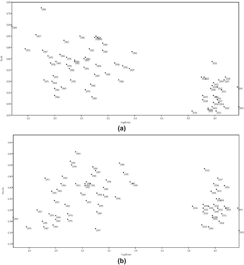
Figure 1 The relationship between the number of fire events (log-transformed, ‘log(fires)’) and the per cent share of high forests (‘For%’, panel (a) and woodlands (‘Woo%’, panel (b) in total burnt area. Source: author’s statistical elaboration of Elstat (Hellenic Statistical Authority) official data.
The relationship between fire size (log-transformed) and the per cent share of high forests in total burnt area (Figure 2(a)) illustrates a more mixed situation compared with the previous analysis. Recent years were clustered in the lower part of the scatterplot, although with no clear spatial pattern (fire size). A similar condition was observed when considering the per cent share of woodland in total burnt area (Figure 2(b)).
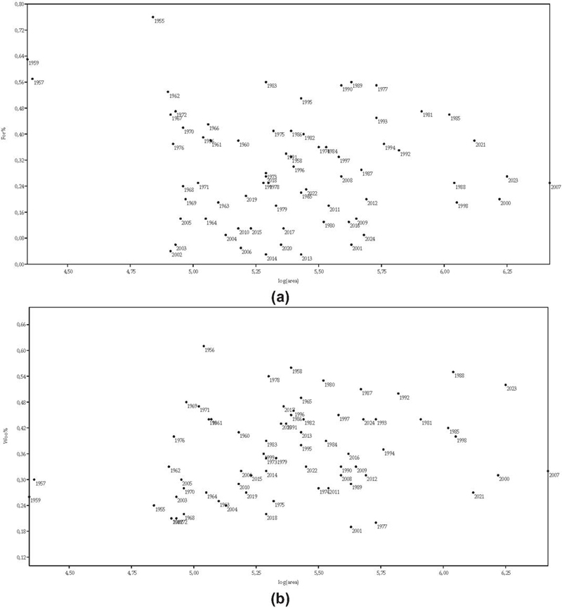
Figure 2 The relationship between fire size (log-transformed, ‘log(area)’) and the per cent share of high forests (‘For%’, panel (a) and woodlands (‘Woo%’, panel (b) in total burnt area. Source: author’s statistical elaboration of Elstat (Hellenic Statistical Authority) official data.
The relationship between the per cent share of high forests and other woodland types in total burnt area (Figure 3) illustrates a more mixed situation compared with previous elaborations. Recent years were clustered in the left side of the scatterplot, and the reverse trend was observed for past years. As in earlier cases, the most relevant variable discriminating among the temporal axis was the per cent share of high forests in total burnt area. Taken together, more recent fires seem to be bigger in size than in the past but are also threatening a lower proportion of high forests than in the past, possibly involving more cropland or other (non-wooded) land-use classes.
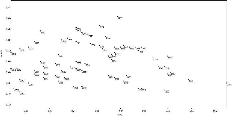
Figure 3 The relationship between the per cent share of high forests (‘For%’) and woodlands (‘Woo%’) in total burnt area. Source: author’s statistical elaboration of Elstat (Hellenic Statistical Authority) official data.
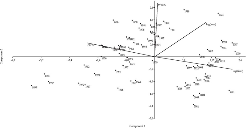
Figure 4 Results of a Principal Component Analysis summarizing the latent complexity of relevant wildfires’ characteristics over time (see Figures 1–2 and text for relevant variables’ acronyms). Source: author’s statistical elaboration of Elstat (Hellenic Statistical Authority) official data.
Multivariate Analysis
An exploratory data analysis was run on the input matrix consisting of four variables (see Table 2) relevant in the investigation of wildfires’ regime made available every year during the period 1955–2024. More specifically, a Principal Component Analysis extracting two main dimensions (PC1: 46.9% and PC2: 30.1%) was adopted here, accounting 77% of the total variance overall. Figure 4 illustrated the results of the analysis based on a traditional biplot graphical representation. Component 1 (horizontal) illustrates a clear temporal gradient moving from past years (left) to recent years (right) and based on the overall frequency of fire events (positively associated with the axis, and thus higher over recent times) and the per cent share of forests in total burnt area (negatively associated with the axis, and thus higher over past times). Being constructed as geometrically independent from Component 1, Component 2 was clearly associated with the per cent share of woodlands in total burnt area, in turn associated with specific years especially in the 1970s, the 1980s and the 1990s. Fire size (‘log(area)’) was basically unrelated with the other analysis’ dimensions and mostly associated with 2023, reaching the highest amount of burnt areas in the country all over the investigated time series.
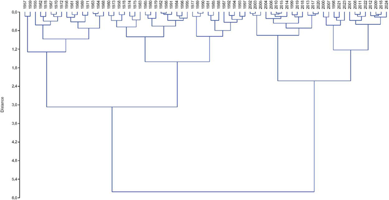
Figure 5 A dendrogram illustrating the results of a hierarchical clustering (Euclidean distances, Ward’s agglomeration rule) classifying years based on the dominant wildfires’ regime as quantified using four relevant variables (‘log(fires)’, ‘log(area)’, ‘For%’ and ‘Woo%’); see Table 2 for descriptive statistics. Source: author’s statistical elaboration of Elstat (Hellenic Statistical Authority) official data.
Figure 5 summarizes the outcome of a hierarchical clustering with Euclidean distances and Ward’s agglomeration rule for input amalgamation. A dendrogram was used to illustrate the results of the analysis and classified years based on the dominant wildfires’ regime quantified considering four relevant variables (‘log(fires)’, ‘log(area)’, ‘For%’ and ‘Woo%’). In line with the outcomes of previous analysis, hierarchical clustering confirmed a clear differentiation in two main groups of years (from 1998 to 2024, right-side, and from 1955 to 1997, left-side). However, a more subtle time division was highlighted, evidencing three sub-groups in the left-side cluster (the initial years in the time series from 1958 to 1968, left, the intermediate years from 1960 to 1995, middle, and the more recent years from 1977 to 1997, right), documenting a progressive shift in the wildfires’ regime toward bigger and more frequent fires in Greece moving from left to right. At the same time, two sub-groups were also observed in the right-side main cluster, distinguishing years from 2002 to 2020 (left side) and from 2000 to 2024 (right side). These two sub-groups indicate homogeneous years with different (overall) conditions of fire danger (lower in the left cluster, higher in the right cluster). Taken together, hierarchical clustering document a continuous worsening of wildfires’ characteristics over time when moving from left to right in the dendrogram.
Discussion
In Mediterranean Europe, anthropogenic influences have historically exerted a disproportionate effect on fire regimes compared with other geographic regions (e.g. De Rosa and Salvati, 2016; Cuadrado-Ciuraneta et al., 2017; Zambon et al., 2019, often amplifying wildfire incidence and severity due to the density of human settlements and intensive land management practices (Fernandes et al., 2020). This regional context has prompted sustained scientific and policy debates regarding the potential of land governance strategies, grounded in bio-economy principles and nature-based solutions, to mitigate wildfire impacts under ongoing and projected climate change scenarios (Moreira and Pe’er, 2018; Verkerk et al., 2018; Ascoli et al., 2022). Financial mechanisms such as the European Rural Development Program and other (research or professional) initiatives have been instrumental in promoting these strategies, enabling the creation of resilient ecosystems (European Commission, 2018). By investigating seven decades of the recent fire history in Greece, this study estimates (apparent and more latent) changes in widfires’ regimes over time, and contributes to more effective and efficient policy implementation strategies.
Across the last seven decades, wildfires in Greece have shown a clear long-term intensification. While some periods were marked by exceptionally large burned surfaces, the overall trend points to more frequent and, in recent years, generally larger fires. At the same time, the share of high forests affected by fires has progressively declined, whereas the proportion of other wooded areas has remained broadly stable, suggesting a growing involvement of agricultural and open landscapes. Latent relationships among the main indicators indicate that years with many fires tend to coincide with larger burned areas and a lower proportion of high forests. More recent decades stand out from earlier ones, being characterized by a higher fire occurrence and a shift in the types of land most affected, reflecting – at least partly – the main landscape changes illustrated briefly in the descriptive analysis whose results are reported in Table 1. Multivariate analyses consistently separate earlier from recent years and highlight a gradual transition toward more severe wildfire regimes over time, with the most recent period representing the highest overall level of fire danger observed in the record.
Based on such results, a diverse suite of measures can be mentioned here aimed at fostering landscapes capable of withstanding wildfire exposure while maintaining essential ecosystem functions (e.g. Fernandes, 2013; Tedim et al., 2016; Bacciu et al., 2022). Indirect prevention approaches seem to be particularly appropriate in the recent context studied in this paper, as they are conceptually embedded within the framework of integrated fire management, which advocates for coordinated, cross-sectoral landscape governance to optimize fire prevention, mitigation, and resilience outcomes (Rego et al., 2010).
By incorporating fire risk reduction objectives into broader land-use (and socio-ecological) management strategies, these integrated measures support the creation of multifunctional landscapes that simultaneously deliver ecological, social, and economic benefits (European Commission, 2018). Moreover, the economic self-sufficiency of many indirect interventions allows them to overcome the spatial and financial constraints that often limit direct, operational fire prevention measures (Wunder et al., 2021), providing scalable and long-term solutions for enhancing landscape resilience under increasingly challenging climatic conditions (Ascoli et al., 2022). Fire prevention strategies have to deal with evolving environmental and socioeconomic scenarios mainly based on landscape transformations (e.g. Zambon et al., 2017). The combination of a warming climate, fuel patterns and socioeconomic conditions are responsible for increasing large fires occurrence throughout Europe. In the latter countries, fires result in more severe and long lasting effects due to the lower fire resistance and resilience of forests.
Conclusions
In order to cope with a changing world, transfer of fire management strategies is highly recommended due to the modified spatial pattern and amount of fuels that allow wildfire to spin out of control. Future research should clarify promptly how fire prevention can make large fire suppression more cost-effective and propose prevention actions based on broader sustainable landscape (forest/non-forest) management to increase wildfires response preparedness. These objectives could be reached more effectively by sharing national, regional and local good practices among countries with different operational experiences and skills, underlying different levels of wildfires response preparedness.
Acknowledgments
This work has been partly supported by the University of Piraeus Research Center.
References
Acácio, V., Holmgren, M., Rego, F., Moreira, F., and Mohren, G. M. J. (2009). Are drought and wildfires turning Mediterranean cork oak forests into persistent shrublands? Agroforestry Systems, 76, 389–400. https://doi.org/10.1007/s10457-008-9165-y.
Adler, N., and Yazhemsky, E. (2010). Improving discrimination in data envelopment analysis: PCA–DEA or variable reduction. European Journal of Operational Research, 202(1), 273–284. https://doi.org/10.1016/j.ejor.2009.03.050.
Akter, S., and Grafton, R. Q. (2021). Do fires discriminate? Socio-economic disadvantage, wildfire hazard exposure and the Australian 2019–20 ‘Black Summer’ fires. Climatic Change, 165, Article 53. https://doi.org/10.1007/s10584-021-03064-6.
Ascoli, D., Castagneri, D., Valsecchi, C., Conedera, M., and Bovio, G. (2013). Post-fire restoration of beech stands in the Southern Alps by natural regeneration. Ecological Engineering, 54, 210–217. https://doi.org/10.1016/j.ecoleng.2013.01.032.
Ascoli, D., Moris, J. V., Marchetti, M., and Sallustio, L. (2021). Land use change towards forests and wooded land correlates with large and frequent wildfires in Italy. Annals of Silvicultural Research, 46(2), 177–188. https://doi.org/10.12899/asr-2264.
Avitabile, V., Pilli, R., and Camia, A. (2020). The biomass of European forests: An integrated assessment of forest biomass maps, field plots and national statistics. Publications Office of the European Union. https://doi.org/10.2760/758855.
Bacciu, V., Sirca, C., and Spano, D. (2022). Towards a systemic approach to fire risk management. Environmental Science & Policy, 129, 37–44. https://doi.org/10.1016/j.envsci.2021.12.015.
Barbati, A., Corona, P., D’Amato, E., and Cartisano, R. (2015). Is landscape a driver of short-term wildfire recurrence? Landscape Research, 40, 99–108. https://doi.org/10.1080/01426397.2012.761681.
Biasi, R., Brunori, E., Ferrara, C., and Salvati, L. (2019). Assessing impacts of climate change on phenology and quality traits of Vitis vinifera L.: The contribution of local knowledge. Plants, 8(5), Article 121. https://doi.org/10.3390/plants8050121.
Canadas, M. J., Leal, M., Soares, F., Novais, A., Ribeiro, P. F., Schmidt, L., and Delicado, A. (2023). Wildfire mitigation and adaptation: Two locally independent actions supported by different policy domains. Land Use Policy, 124, Article 106444. https://doi.org/10.1016/j.landusepol.2022.106444.
Cánibe Iglesias, M., Hermoso, V., Campos, J. C., Carvalho-Santos, C., Fernandes, P. M., Freitas, T. R., Honrado, J., Santos, J. A., Sil, Â., Regos, A., and Azevedo, J. C. (2022). Climate- and fire-smart landscape scenarios call for redesigning protection regimes to achieve multiple management goals. SSRN Electronic Journal. https://doi.org/10.2139/ssrn.4141771.
Cansler, A. C., Kane, V. R., Hessburg, P. F., Kane, J. T., Jeronimo, S. M. A., Lutz, J. A., Povak, N. A., Churchill, D. J., and Larson, A. J. (2021). Previous wildfires and management treatments moderate subsequent fire severity. Forest Ecology and Management, 504, Article 119764. https://doi.org/10.1016/j.foreco.2021.119764.
Chirici, G., Giannetti, F., Mazza, E., Francini, S., Travaglini, D., Pegna, R., and White, J. C. (2020). Monitoring clearcutting and subsequent rapid recovery in Mediterranean coppice forests with Landsat time series. Annals of Forest Science, 77, Article 40. https://doi.org/10.1007/s13595-020-00936-2.
Clark, M. R., and Kozar, J. S. (2011). Comparing sustainable forest management certification standards: A meta-analysis. Ecology and Society, 16(1), Article 3.
Colantoni, A., Ferrara, C., Perini, L., and Salvati, L. (2015). Assessing trends in climate aridity and vulnerability to soil degradation in Italy. Ecological Indicators, 48, 599–604. https://doi.org/10.1016/j.ecolind.2014.10.031.
Colonico, M., Tomao, A., Ascoli, D., Corona, P., Giannino, F., Moris, J. V., Romano, R., Salvati, L., and Barbati, A. (2022). Rural development funding and wildfire prevention: Evidence of spatial mismatches with fire activity. Land Use Policy, 117, Article 106079. https://doi.org/10.1016/j.landusepol.2022.106079.
Corona, P., Ascoli, D., Barbati, A., Bovio, G., Colangelo, G., Elia, M., Garfì, V., Iovino, F., Lafortezza, R., Leone, V., Lovreglio, R., Marchetti, M., Marchi, E., Menguzzato, G., Nocentini, S., Picchio, R., Portoghesi, L., Puletti, N., Sanesi, G., and Chianucci, F. (2015). Integrated forest management to prevent wildfires under Mediterranean environments. Annals of Silvicultural Research, 39, 1–22. https://doi.org/10.12899/ASR-946.
Cuadrado-Ciuraneta, S., Durà-Guimerà, A., and Salvati, L. (2017). Not only tourism: Unravelling suburbanization, second-home expansion and “rural” sprawl in Catalonia, Spain. Urban Geography, 38(1), 66–89.
Dale, V. H. (1997). The relationship between land-use change and climate change. Ecological Applications, 7(3), 753–769. https://doi.org/10.1890/1051-0761.
De Rosa, S., and Salvati, L. (2016). Beyond a ‘side street story’? Naples from spontaneous centrality to entropic polycentricism, towards a ‘crisis city’. Cities, 51, 74–83.
Egidi, G., Salvati, L., and Vinci, S. (2020). The long way to Tipperary: City size and worldwide urban population trends, 1950–2030. Sustainable Cities and Society, 60, Article 102148. https://doi.org/10.1016/j.scs.2020.102148.
Espinosa, J., Palheiro, P., Loureiro, C., Ascoli, D., Esposito, A., and Fernandes, P. M. (2019). Fire-severity mitigation by prescribed burning assessed from fire-treatment encounters in maritime pine stands. Canadian Journal of Forest Research, 49(2), 205–211. https://doi.org/10.1139/cjfr-2018-0263.
Fares, S., Bajocco, S., Salvati, L., Camarretta, N., Dupuy, J.-L., Xanthopoulos, G., Guijarro, M., Madrigal, J., Hernando, C., and Corona, P. (2017). Characterizing potential wildland fire fuel in live vegetation in the Mediterranean region. Annals of Forest Science, 74, Article 1. https://doi.org/10.1007/s13595-016-0611-1.
Feranec, J., Soukup, T., Hazeu, G., and Jaffrain, G. (2016). European landscape dynamics: CORINE land cover data. CRC Press, London.
Fernandes, P. M. (2013). Fire-smart management of forest landscapes in the Mediterranean basin under global change. Landscape and Urban Planning, 110, 175–182. https://doi.org/10.1016/j.landurbplan.2012.10.014.
Fernandes, P. M., Monteiro-Henriques, T., Guiomar, N., Loureiro, C., and Barros, A. M. G. (2016). Bottom-up variables govern large fire size in Portugal. Ecosystems, 19, 1362–1375. https://doi.org/10.1007/s10021-016-0010-2.
Ferrara, A., Kelly, C., Wilson, G. A., Nolè, A., Mancino, G., Bajocco, S., and Salvati, L. (2016). Shaping the role of “fast” and “slow” drivers of change in forest–shrubland socio-ecological systems. Journal of Environmental Management, 169, 155–166. https://doi.org/10.1016/j.jenvman.2015.12.037.
Ferrara, A., Kosmas, C., Salvati, L., Padula, A., Mancino, G., and Nolè, A. (2020). Updating the MEDALUS-ESA framework for worldwide land degradation and desertification assessment. Land Degradation & Development, 31(12), 1593–1607. https://doi.org/10.1002/ldr.3537.
Ferrara, C., Carlucci, M., Grigoriadis, E., Corona, P., and Salvati, L. (2017). A comprehensive insight into the geography of forest cover in Italy: Exploring the importance of socioeconomic local contexts. Forest Policy and Economics, 75, 12–22. https://doi.org/10.1016/j.forpol.2016.12.003.
Ferrara, C., Salvati, L., Corona, P., Romano, R., and Marchi, M. (2019). The background context matters: Local-scale socioeconomic conditions and the spatial distribution of wildfires in Italy. Science of the Total Environment, 654, 43–52. https://doi.org/10.1016/j.scitotenv.2018.11.049.
Ferretti, M., Marchetto, A., Arisci, S., Bussotti, F., Calderisi, M., Carnicelli, S., Cecchini, G., Fabbio, G., Bertini, G., Matteucci, G., de Cinti, B., Salvati, L., and Pompei, E. (2014). On the tracks of nitrogen deposition effects on temperate forests at their southern European range: An observational study from Italy. Global Change Biology, 20(11), 3423–3438. https://doi.org/10.1111/gcb.12552.
Fick, S. E., and Hijmans, R. J. (2017). WorldClim 2: New 1 km spatial resolution climate surfaces for global land areas. International Journal of Climatology, 37, 4302–4315. https://doi.org/10.1002/joc.5086.
Field, R. D., Spessa, A. C., Aziz, N. A., Camia, A., Cantin, A., Carr, R., de Groot, W. J., Dowdy, A. J., Flannigan, M. D., Manomaiphiboon, K., Pappenberger, F., Tanpipat, V., and Wang, X. (2015). Development of a global fire weather database. Natural Hazards and Earth System Sciences, 15, 1407–1423. https://doi.org/10.5194/nhess-15-1407-2015.
Francaviglia, R., Di Bene, C., Farina, R., Salvati, L., and Vicente-Vicente, J. L. (2019). Assessing “4 per 1000” soil organic carbon storage rates under Mediterranean climate: A comprehensive data analysis. Mitigation and Adaptation Strategies for Global Change, 24, 795–818. https://doi.org/10.1007/s11027-018-9828-3.
Francini, S., McRoberts, R. E., D’Amico, G., Coops, N. C., Hermosilla, T., White, J. C., Wulder, M. A., Marchetti, M., Scarascia Mugnozza, G., and Chirici, G. (2022). An open science and open data approach for the statistically robust estimation of forest disturbance areas. International Journal of Applied Earth Observation and Geoinformation, 106, Article 102663. https://doi.org/10.1016/j.jag.2021.102663.
Francini, S., McRoberts, R. E., Giannetti, F., Marchetti, M., Scarascia Mugnozza, G., and Chirici, G. (2021). The Three Indices Three Dimensions (3I3D) algorithm: A new method for forest disturbance mapping and area estimation based on optical remotely sensed imagery. International Journal of Remote Sensing, 42(12), 4693–4711. https://doi.org/10.1080/01431161.2021.1899334.
Gallego Fernández, J. B., García Mora, M. R., and García Novo, F. (2004). Vegetation dynamics of Mediterranean shrublands in former cultural landscapes at Grazalema Mountains, southern Spain. Plant Ecology, 172, 83–94. https://doi.org/10.1023/B:VEGE.0000026039.00969.7a.
García-Llamas, P., Suárez-Seoane, S., Taboada, A., Fernández-Manso, A., Quintano, C., Fernández-García, V., Fernández-Guisuraga, J. M., Marcos, E., and Calvo, L. (2019). Environmental drivers of fire severity in extreme fire events affecting Mediterranean pine forest ecosystems. Forest Ecology and Management, 433, 24–32. https://doi.org/10.1016/j.foreco.2018.10.051.
García-Ruiz, J. M., Lasanta, T., Nadal-Romero, E., Lana-Renault, N., and Álvarez-Farizo, B. (2020). Rewilding and restoring cultural landscapes in Mediterranean mountains: Opportunities and challenges. Land Use Policy, 99, Article 104850. https://doi.org/10.1016/j.landusepol.2020.104850.
Hansen, M. C., Potapov, P. V., Moore, R., Hancher, M., Turubanova, S. A., Tyukavina, A., Thau, D., Stehman, S. V., Goetz, S. J., Loveland, T. R., Kommareddy, A., Egorov, A., Chini, L., Justice, C. O., and Townshend, J. R. G. (2013). High-resolution global maps of 21st-century forest cover change. Science, 342, 850–853. https://doi.org/10.1126/science.1244693.
Humphrey, J. G., Gillson, L., and Ziervogel, G. (2021). How changing fire management policies affect fire seasonality and livelihoods. Ambio, 50(2), 475–491. https://doi.org/10.1007/s13280-020-01351-7.
Imbrenda, V., Quaranta, G., Salvia, R., Egidi, G., Salvati, L., Prokopová, M., Coluzzi, R., and Lanfredi, M. (2021). Land degradation and metropolitan expansion in a peri-urban environment. Geomatics, Natural Hazards and Risk, 12(1), 1797–1818. https://doi.org/10.1080/19475705.2021.1946627.
Incerti, G., Feoli, E., Salvati, L., Brunetti, A., and Giovacchini, A. (2007). Analysis of bioclimatic time series and their neural network-based classification to characterise drought risk patterns in southern Italy. International Journal of Biometeorology, 51, 253–263. https://doi.org/10.1007/s00484-006-0079-3.
Jain, P., Coogan, S. C. P., Ganapathi Subramanian, S., Crowley, M., Taylor, S., and Flannigan, M. D. (2020). A review of machine learning applications in wildfire science and management. Environmental Reviews, 28(4), 478–505. https://doi.org/10.1139/er-2020-0019.
James, P. M. A., Fortin, M.-J., Sturtevant, B. R., Fall, A., Kneeshaw, D., and Messier, C. (2011). Modelling spatial interactions among fire, spruce budworm, and logging in the boreal forest. Ecosystems, 14, 60–75. https://doi.org/10.1007/s10021-010-9395-5.
Kairis, O., Karavitis, C., Salvati, L., Kounalaki, A., and Kosmas, C. (2015). Exploring the impact of overgrazing on soil erosion and land degradation in a Mediterranean agroforestry landscape (Crete, Greece). Arid Land Research and Management, 29(3), 360–374. https://doi.org/10.1080/15324982.2014.968691.
Kane, V. R., Cansler, C. A., Povak, N. A., Kane, J. T., McGaughey, R. J., Lutz, J. A., Churchill, D. J., North, M. P., and Larson, A. J. (2015). Mixed severity fire effects within the Rim Fire: Relative importance of local climate, fire weather, topography, and forest structure. Forest Ecology and Management, 358, 62–79. https://doi.org/10.1016/j.foreco.2015.09.001.
Karali, A., Hatzaki, M., Karacostas, T., Giannakopoulos, C., and Maheras, P. (2014). Sensitivity and evaluation of current fire risk and future projections due to climate change: The case study of Greece. Natural Hazards and Earth System Sciences, 14, 143–153. https://doi.org/10.5194/nhess-14-143-2014.
Keeley, J. E., and Syphard, A. D. (2016). Climate change and future fire regimes: Examples from California. Geosciences, 6(3), Article 37. https://doi.org/10.3390/geosciences6030037.
Koutsias, N., Martínez-Fernández, J., and Allgöwer, B. (2010). Do factors causing wildfires vary in space? Evidence from geographically weighted regression. GIScience & Remote Sensing, 47(2), 221–240. https://doi.org/10.2747/1548-1603.47.2.221.
Krawchuk, M. A., Moritz, M. A., Parisien, M.-A., Van Dorn, J., and Hayhoe, K. (2009). Global pyrogeography: The current and future distribution of wildfire. PLoS ONE, 4(4), Article e5102. https://doi.org/10.1371/journal.pone.0005102.
Lasanta, T., Arnáez, J., Pascual, N., Ruiz-Flaño, P., Errea, M. P., and Lana-Renault, N. (2017). Space–time process and drivers of land abandonment in Europe. Catena, 149, 810–823. https://doi.org/10.1016/j.catena.2016.02.024.
Leone, V., Lovreglio, R., and Mavsar, R. (2014). Wildfire management in Mediterranean countries: Current approaches and future needs. Forest Systems, 23(2), 125–130.
Moreira, F., Ascoli, D., Safford, H., Adams, M. A., Moreno, J. M., Pereira, J. M. C., Catry, F. X., Armesto, J., Bond, W., González, M. E., Curt, T., Koutsias, N., McCaw, L., Price, O., Pausas, J. G., Rigolot, E., Stephens, S. L., Tavşanoğlu, Ç., Vallejo, V. R., and Xanthopoulos, G. (2020). Wildfire management in Mediterranean-type regions: Paradigm change needed. Environmental Research Letters, 15(1), Article 011001. https://doi.org/10.1088/1748-9326/ab541e.
Moreira, F., Rego, F. C., and Ferreira, P. G. (2001). Temporal (1958–1995) pattern of change in a cultural landscape of northwestern Portugal: Implications for fire occurrence. Landscape Ecology, 16, 557–567. https://doi.org/10.1023/A:1013130528470.
Moreno, J. M., Vázquez, A., and Vélez, R. (1998). Recent history of forest fires in Spain. In J. M. Moreno (Ed.), Large forest fires (pp. 159–185). Backhuys, Amsterdam.
Nocentini, S., Buttoud, G., Ciancio, O., and Corona, P. (2017). Managing forests in a changing world: The need for a systemic approach. A review. Forest Systems, 26(1), Article eR01. https://doi.org/10.5424/fs/2017261-09443.
Parisien, M.-A., Miller, C., Ager, A. A., and Finney, M. A. (2010). Use of artificial landscapes to isolate controls on burn probability. Landscape Ecology, 25, 79–93. https://doi.org/10.1007/s10980-009-9398-7.
Pausas, J. G., and Fernández-Muñoz, S. (2012). Fire regime changes in the Western Mediterranean Basin: From fuel-limited to drought-driven fire regime. Climatic Change, 110, 215–226. https://doi.org/10.1007/s10584-011-0060-6.
Pausas, J. G., and Keeley, J. E. (2019). Wildfires as an ecosystem service. Frontiers in Ecology and the Environment, 17(5), 289–295. https://doi.org/10.1002/fee.2044.
Pausas, J. G., and Ribeiro, E. (2017). Fire and plant diversity at the global scale. Global Ecology and Biogeography, 26(8), 889–897. https://doi.org/10.1111/geb.12596.
Pereira, M. G., Trigo, R. M., da Camara, C. C., Pereira, J. M. C., and Leite, S. M. (2005). Synoptic patterns associated with large summer forest fires in Portugal. Agricultural and Forest Meteorology, 129, 11–25. https://doi.org/10.1016/j.agrformet.2004.12.007.
Pérez-Cabello, F., de la Riva, J., Montorio, R., and García-Martín, A. (2011). Mapping erosion-sensitive areas after wildfires using fieldwork, remote sensing, and geographic information systems: A case study in the Central Spanish Pyrenees. Catena, 84(1–2), 48–57. https://doi.org/10.1016/j.catena.2010.09.005.
Regos, A., Aquilué, N., López, I., Codina, M., Retana, J., and Brotons, L. (2016). Synergies between forest biomass extraction for bioenergy and fire suppression in Mediterranean ecosystems: Insights from a landscape model. Ecosystems, 19, 786–802. https://doi.org/10.1007/s10021-016-9968-3.
Salvati, L., Bajocco, S., Ceccarelli, T., Zitti, M., and Perini, L. (2011). Towards a process-based evaluation of land vulnerability to soil degradation in Italy. Ecological Indicators, 11(5), 1216–1227. https://doi.org/10.1016/j.ecolind.2011.01.010.
Salvati, L., Colantoni, A., Ferrara, C., Perini, L., and Carlucci, M. (2015). Towards sustainable land management? The role of socioeconomic local contexts in forest landscape dynamics. Land Use Policy, 49, 1–11. https://doi.org/10.1016/j.landusepol.2015.07.024.
Salvati, L., Ferrara, A., Carlucci, M., and Corona, P. (2018). Exploring changes in forest landscapes under socioeconomic and environmental pressure: A spatial analysis of Italy. Environmental Management, 62, 876–890. https://doi.org/10.1007/s00267-018-1082-6.
Salvati, L., Perini, L., Sabbi, A., and Bajocco, S. (2012). Climate aridity and land use changes: A regionalscale analysis. Geographical Research, 50(2), 193–203. https://doi.org/10.1111/j.1745-5871.2012.00756.x.
Salvati, L., Ranalli, F., Carlucci, M., Ippolito, A., Ferrara, A., and Corona, P. (2017). Forest and the city: A multivariate analysis of peri-urban forest land cover patterns in 283 European metropolitan areas. Ecological Indicators, 73, 369–377. https://doi.org/10.1016/j.ecolind.2016.09.037.
Salvati, L., Tombolini, I., Perini, L., and Ferrara, A. (2013). Landscape changes and environmental quality: The evolution of land vulnerability and potential resilience to degradation in Italy. Regional Environmental Change, 13, 1223–1233. https://doi.org/10.1007/s10113-013-0440-2.
Salvati, L., Venanzoni, G., Serra, P., and Carlucci, M. (2016). Scattered or polycentric? Untangling urban growth in three southern European metropolitan regions through exploratory spatial data analysis. The Annals of Regional Science, 57, 1–29. https://doi.org/10.1007/s00168-016-0775-1.
Santopuoli, G., Ferranti, F., and Marchetti, M. (2015). Implementing criteria and indicators for sustainable forest management in a decentralized setting: Italy as a case study. Journal of Environmental Policy & Planning, 18(2), 177–196. https://doi.org/10.1080/1523908X.2015.1065718.
Schober, P., Boer, C., and Schwarte, L. A. (2018). Correlation coefficients: Appropriate use and interpretation. Anesthesia & Analgesia, 126(5), 1763–1768. https://doi.org/10.1213/ANE.0000000000002864.
Seifollahi-Aghmiuni, S., Kalantari, Z., Egidi, G., Gaburova, L., and Salvati, L. (2022). Urbanisation-driven land degradation and socioeconomic challenges in peri-urban areas: Insights from Southern Europe. Ambio, 51(6), 1446–1458. https://doi.org/10.1007/s13280-021-01650-7.
Sil, Â., Fernandes, P. M., Rodrigues, A. P., Alonso, J. M., Honrado, J. P., Perera, A., and Azevedo, J. C. (2019). Farmland abandonment decreases the fire regulation capacity and the fire protection ecosystem service in mountain landscapes. Ecosystem Services, 36, 100908. https://doi.org/10.1016/j.ecoser.2019.100908.
Stritih, A., Senf, C., Seidl, R., Grêt-Regamey, A., and Bebi, P. (2021). The impact of land-use legacies and recent management on natural disturbance susceptibility in mountain forests. Forest Ecology and Management, 484, 118950. https://doi.org/10.1016/j.foreco.2021.118950.
Taylor Jr, C. A. (2006). Targeted grazing to manage fire risk. In D. L. Johnson, R. K. Jones, and S. Smith (Eds.), Targeted grazing: A natural approach to vegetation management and landscape enhancement (pp. 107–112). USDA Forest Service, Washington, DC.
Tedim, F., Leone, V., and Xanthopoulos, G. (2016). A wildfire risk management concept based on a social-ecological approach in the European Union: Fire Smart Territory. International Journal of Disaster Risk Reduction, 18, 138–153. https://doi.org/10.1016/j.ijdrr.2016.06.005.
Tomao, A., Quatrini, V., Corona, P., Ferrara, A., Lafortezza, R., and Salvati, L. (2017). Resilient landscapes in Mediterranean urban areas: Understanding factors influencing forest trends. Environmental Research, 156, 1–9. https://doi.org/10.1016/j.envres.2017.03.038.
Varela, E., Pulido, F., Moreno, G., and Zavala, M. Á. (2020). Targeted policy proposals for managing spontaneous forest expansion in the Mediterranean. Journal of Applied Ecology, 57, 2373–2380. https://doi.org/10.1111/1365-2664.13779.
Verkerk, P. J., Martinez de Arano, I., and Palahí, M. (2018). The bio-economy as an opportunity to tackle wildfires in Mediterranean forest ecosystems. Forest Policy and Economics, 86, 1–3. https://doi.org/10.1016/j.forpol.2017.10.016.
Viedma, O., Moity, N., and Moreno, J. M. (2015). Changes in landscape fire-hazard during the second half of the 20th century: Agriculture abandonment and the changing role of driving factors. Agriculture, Ecosystems & Environment, 207, 126–140. https://doi.org/10.1016/j.agee.2015.04.011.
Viedma, O., Urbieta, I. R., and Moreno, J. M. (2018). Wildfires and the role of their drivers are changing over time in a large rural area of west-central Spain. Scientific Reports, 8, 17797. https://doi.org/10.1038/s41598-018-36134-4.
Vilar, L., Gómez, I., Martínez-Vega, J., Echavarría, P., Riaño, D., and Martín, M. P. (2016). Multitemporal modelling of socio-economic wildfire drivers in central Spain between the 1980s and the 2000s: Comparing generalized linear models to machine learning algorithms. PLoS ONE, 11(7), e0161344. https://doi.org/10.1371/journal.pone.0161344.
Vitolo, C., Di Giuseppe, F., Barnard, C., Coughlan, R., San-Miguel-Ayanz, J., Libertá, G., and Krzeminski, B. (2020). ERA5-based global meteorological wildfire danger maps. Scientific Data, 7, 216. https://doi.org/10.1038/s41597-020-0554-z.
Vitolo, C., Di Giuseppe, F., Krzeminski, B., and San-Miguel-Ayanz, J. (2019). A 1980–2018 global fire danger re-analysis dataset for the Canadian Fire Weather Indices. Scientific Data, 6, 190032. https://doi.org/10.1038/sdata.2019.32.
Wilson, G. A., Kelly, C. L., Briassoulis, H., Ferrara, A., Quaranta, G., Salvia, R., Detsis, V., Curfs, M., Cerda, A., El-Aich, A., Liu, H., Kosmas, C., Alados, C. L., Imeson, A., Landgrebe-Trinkunaite, R., Salvati, L., Naumann, S., Danwen, H., Iosifides, T., and Kizos, T. (2017). Social memory and the resilience of communities affected by land degradation. Land Degradation & Development, 28(2), 383–400. https://doi.org/10.1002/ldr.2652.
Wunder, S., Calkin, D. E., Charlton, V., Feder, S., Martínez de Arano, I., Moore, P., Rodríguez y Silva, F., Tacconi, L., and Vega-García, C. (2021). Resilient landscapes to prevent catastrophic forest fires: Socioeconomic insights towards a new paradigm. Forest Policy and Economics, 128, 102458. https://doi.org/10.1016/j.forpol.2021.102458.
Zambon, I., Colantoni, A., Carlucci, M., Morrow, N., Sateriano, A., and Salvati, L. (2017). Land quality, sustainable development and environmental degradation in agricultural districts: A computational approach based on entropy indexes. Environmental Impact Assessment Review, 64, 37–46.
Zambon, I., Colantoni, A., and Salvati, L. (2019). Horizontal vs vertical growth: Understanding latent patterns of urban expansion in large metropolitan regions. Science of the Total Environment, 654, 778–785.
Zuur, A. F., Ieno, E. N., and Elphick, C. S. (2010). A protocol for data exploration to avoid common statistical problems. Methods in Ecology and Evolution, 1(1), 3–14. https://doi.org/10.1111/j.2041-210X.2009.00001.x.
Journal of Reliability and Statistical Studies, Vol. 19, Issue 2 (2026), 425–448
doi: 10.13052/jrss0974-8024.1928
© 2026 River Publishers